


Waverley has just pulled back the curtain on a major decade-long plan to overhaul the local walking network, proposing 162 distinct upgrades to make the area safer and easier to navigate on foot.
The draft “Walking Waverley” strategy is officially open for public feedback, giving residents until Tuesday, July 7, 2026, to weigh in on how their local streets will evolve.
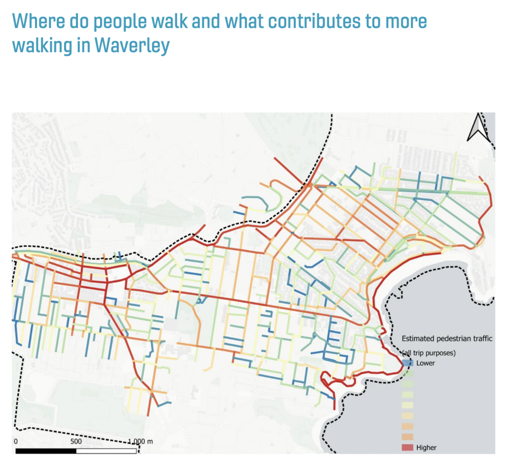
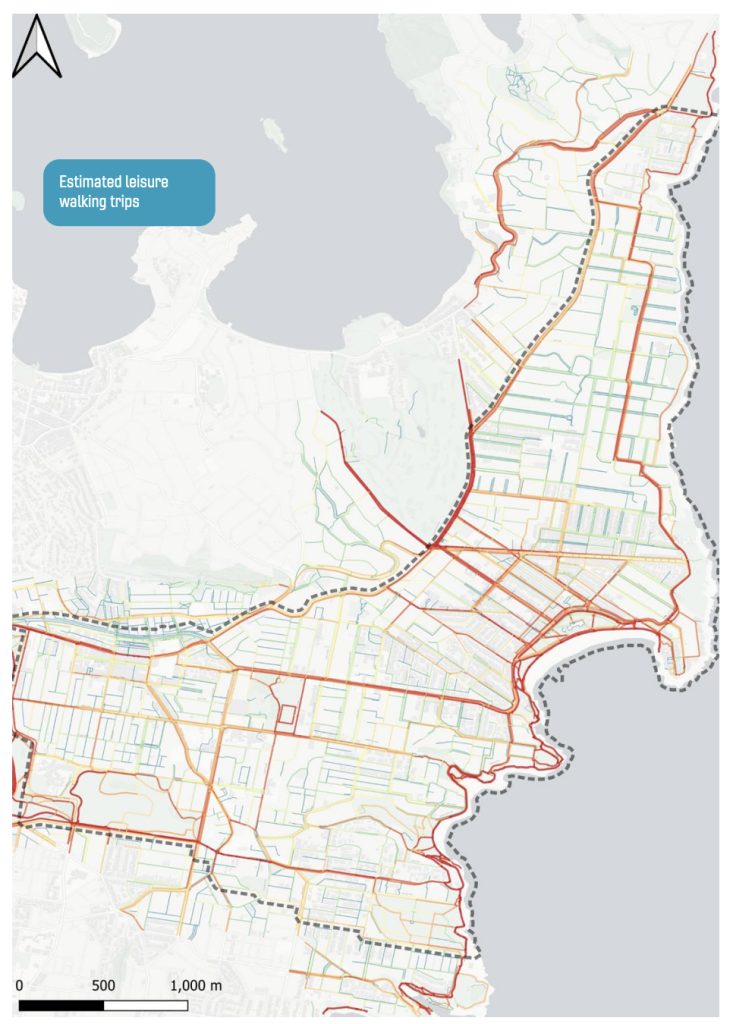
The ambitious project comes at a critical time for the municipality. Waverley is already incredibly compact, and because building new roads simply isn’t an option, walking has become the backbone of local transit.
In fact, more than a third of all trips across the area are made entirely on foot, a figure that jumps to roughly half when you factor in public transport commuters. However, many of the busiest corridors were originally engineered during an era that prioritised cars over people, creating a growing logjam for pedestrians.
Earlier Consultation Identified Common Walking Concerns
The strategy was prepared following community consultation in 2024 and forms part of a broader planning framework that includes the Community Strategic Plan, the People, Movement and Places plan, the Environmental Action Plan and the Disability Inclusion Action Plan.
Feedback collected during the first phase of consultation pointed to several recurring concerns raised by residents. They identified speeding vehicles, limited opportunities to cross roads, footpath conditions and obstructions on pedestrian routes among the most common issues affecting their walking experience.
The consultation also found support for wider footpaths, additional shade from street trees, improved crossings and reduced waiting times at traffic signals.
Strategy Proposes Improvements Across Streets, Centres and Transport Links
The draft strategy identifies 162 opportunities that could be considered over the next 10 years. These opportunities are grouped into several focus areas covering pedestrian safety, crossings, accessibility, school travel, public transport connections and footpath upgrades.
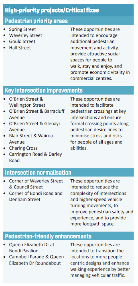
Among the proposals are measures intended to reduce vehicle speeds in selected locations, improvements to intersections, additional pedestrian crossing opportunities and upgrades to footpath surfaces.
The strategy also includes proposals aimed at improving pedestrian movement near bus stops and reducing delays for people crossing roads at signalised intersections. Some of these measures would require collaboration with Transport for NSW, which manages traffic signals and state roads within the area.
| Focus Area | What It Covers |
| Slow Streets | Expansion of 40 km/h zones and other measures to reduce vehicle speeds based on local street conditions and surrounding land uses. |
| Right-Sizing Intersections | Changes to intersections that currently prioritise vehicle movement, with the aim of improving pedestrian access, safety and comfort. |
| Vehicle Entrances and Exits | Measures to reinforce pedestrian priority and improve safety where vehicles cross footpaths at driveways, car parks and access points. |
| Pedestrian Safety Initiatives | Infrastructure upgrades at pedestrian crash locations, combined with community education and awareness programs to improve safety outcomes. |
| Pedestrian Crossing Improvements | Additional crossing opportunities and treatments designed to make road crossings safer, easier and more direct for pedestrians. |
| Pedestrian Signal Priority | Collaboration with Transport for NSW to reduce waiting times at traffic signals, particularly in areas with high pedestrian activity. |
| Bus Stop Improvements | Better pedestrian access around bus stops, including safer street crossings and additional footpath space for waiting passengers and pedestrians. |
| Footpath Surface Improvements | Upgrades to footpaths, streetscapes and walking routes, including heavily used unpaved sections and links through parks and open spaces. |
| Active Travel to School | Continued engagement with schools and pursuit of external funding to improve walking routes and support safer journeys to and from school. |
| Continuous Travel Paths | Accessibility improvements that support the Disability Inclusion Action Plan, including continuous and accessible routes for people with mobility limitations. |
Consultation Open Until 7 July
Following the consultation period, submissions will be reviewed before the strategy is finalised. The document states that implementation of future projects would occur progressively over time, supported through long-term financial planning and external funding opportunities where available.
Published 10-June-2026